Overview
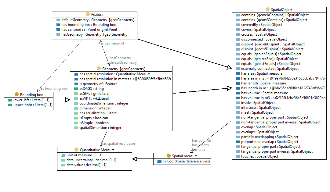
Figure 1: Ontology overview
http://linked.data.gov.au/def/geoxAn extension to GeoSPARQL with new features for the representation of additional elements of feature geometry, such as spatial-resolution, length, area and volume.
| IRI | http://linked.data.gov.au/def/geox#BBox |
|---|---|
| Description |
The two corners should be specified using the same CRS. The edges/faces of the box align with the axes of the CRS used for the corners. |
| Example |
ex:BB99
      rdf:type geox:BBox ;
      geox:lowerLeft "<http://www.opengis.net/def/crs/OGC/1.3/CRS84> POINT(138 -29.5)"^^geo:wktLiteral ;
      geox:upperRight "<http://www.opengis.net/def/crs/OGC/1.3/CRS84> POINT(155 -9)"^^geo:wktLiteral ;
.
ex:BB88
      rdf:type geox:BBox ;
      geox:lowerLeft "{\"type\":\"Point\",\"coordinates\":[138, -29.179266]}"^^rdf:JSON ;
      geox:upperRight "{\"type\":\"Point\",\"coordinates\":[153.577908, -8.998516]}"^^rdf:JSON ;
.
|
| Super-classes |
geo:Geometryc |
| Restrictions |
geox:upperRightdp exactly 1 geox:lowerLeftdp exactly 1 |
| In domain of |
geox:upperRightdp geox:lowerLeftdp |
| In range of |
geox:hasBBoxop |
| IRI | http://linked.data.gov.au/def/geox#SpatialMeasure |
|---|---|
| Description |
Scalar quantity computed or defined within a specified coordinate reference system |
| Example |
                      auspix:R7430551
  rdf:type geo:Feature ;
  geox:hasArea [
       rdf:type geox:SpatialMeasure ;
       data:uncertainty 1.5 ;
       data:unit <http://qudt.org/vocab/unit/M2> ;
       data:value 17793623.0 ;
     ] ;
.
|
| Super-classes |
data:QuantitativeMeasurec |
| Restrictions |
geox:inCRSop exactly 1 |
| In range of |
geox:hasAreaop geox:hasLengthop geox:hasVolumeop |
| IRI | http://linked.data.gov.au/def/geox#hasArea |
|---|---|
| Description | The area of a spatial object, expressed as a scaled number |
| Example |
auspix:R7430551
rdf:type geo:Feature ;
geox:hasArea [
data:uncertainty 1.5 ;
data:unit
|
| Domain(s) | geo:SpatialObjectc |
| Range(s) | geox:SpatialMeasurec |
| IRI | http://linked.data.gov.au/def/geox#hasAreaM2 |
|---|---|
| Description | The area of the spatial object in m^2 |
| Example |
auspix:R7430551
rdf:type geo:Feature ;
geox:hasAreaM2 [
data:value 17793623.0 ;
] ;
geo:hasGeometry [
rdf:type sf:Polygon ;
geo:asWKT "POLYGON((131.02880658436214 -25.331112553792963 , 131.06995884773661 -25.331112553792963 , 131.06995884773661 -25.36980468021464 , 131.02880658436214 -25.36980468021464 , 131.02880658436214 -25.331112553792963))"^^geo:wktLiteral ;
] ;
rdfs:seeAlso
|
| Super-properties | geox:hasAreaop |
| IRI | http://linked.data.gov.au/def/geox#hasBBox |
|---|---|
| Description | the bounding box or envelope of the feature |
| Example |
auspix:R7430551 a geo:Feature ;
geox:hasBBox [
rdf:type geox:BBox ;
geox:lowerLeft "
|
| Super-properties | geo:hasGeometry |
| Range(s) | geox:BBoxc |
| IRI | http://linked.data.gov.au/def/geox#hasCentroid |
|---|---|
| Description | link to the geometric centroid, which is the arithmetic mean position of all the points in the 2-D figure |
| Example |
auspix:R7430551 a geo:Feature ;
geox:hasCentroid [
rdf:type sf:Point ;
geo:asWKT "POINT(131.0493827160494, -25.350457086495783)"^^geo:wktLiteral ;
] ;
geo:hasGeometry [
rdf:type sf:Polygon ;
geo:asWKT "POLYGON((131.02880658436214 -25.331112553792963 , 131.06995884773661 -25.331112553792963 , 131.06995884773661 -25.36980468021464 , 131.02880658436214 -25.36980468021464 , 131.02880658436214 -25.331112553792963))"^^geo:wktLiteral ;
] ;
rdfs:seeAlso
|
| Super-properties | geo:hasGeometry |
| Range(s) | http://www.opengis.net/ont/sf#Pointc http://www.opengis.net/ont/gml#Pointc |
| IRI | http://linked.data.gov.au/def/geox#hasLength |
|---|---|
| Description | The length of a spatial object, expressed as a scaled number |
| Example |
my:road456
:hasLength [
data:uncertainty 5.0 ;
data:unit
|
| Domain(s) | geo:SpatialObjectc |
| Range(s) | geox:SpatialMeasurec |
| IRI | http://linked.data.gov.au/def/geox#hasLengthM |
|---|---|
| Description | The length of a spatial object in metres |
| Example |
my:road456
  :hasLengthM [
    data:value 234.0 ;
  ] ;
.
|
| Super-properties | geox:hasLengthop |
| IRI | http://linked.data.gov.au/def/geox#hasResolution |
|---|---|
| Description | The spatial resolution of the Geometry object, expressed as a linear measurement. |
| Example |
my:image456
:hasResolution [
data:unit
|
| Domain(s) | geo:Geometryc |
| Range(s) | data:QuantitativeMeasurec |
| IRI | http://linked.data.gov.au/def/geox#hasResolutionM |
|---|---|
| Description | The spatial resolution of the Geometry object, expressed as a linear distance in metres |
| Example |
my:image456
  :hasResolutionM [
    data:value 30.0 ;
  ] ;
.
|
| Super-properties | geox:hasResolutionop |
| Domain(s) | geo:Geometryc |
| IRI | http://linked.data.gov.au/def/geox#hasVolume |
|---|---|
| Description | The volume of a spatial object, expressed as a scaled number |
| Example |
my:swimmingPool99
:hasVolume [
data:unit
|
| Domain(s) | geo:SpatialObjectc |
| Range(s) | geox:SpatialMeasurec |
| IRI | http://linked.data.gov.au/def/geox#hasVolumeM3 |
|---|---|
| Description | The volume of a spatial object in cubic-metres |
| Example |
my:swimmingPool99
  :hasVolumeM3 [
    data:value 3050.0 ;
  ] ;
.
|
| Super-properties | geox:hasVolumeop |
| IRI | http://linked.data.gov.au/def/geox#inCRS |
|---|---|
| Description | Geometry, position or measure is defined or computed using this CRS. The CRS should be denoted by a URI Reference to a CRS definition, e.g. https://www.opengis.net/def/crs/EPSG/0/4326 |
| Example |
auspix:R7430551
rdf:type geo:Feature ;
geox:hasArea [
rdf:type geox:SpatialMeasure ;
data:uncertainty 1.5 ;
data:unit
|
| IRI | http://linked.data.gov.au/def/geox#isGeometryOf |
|---|---|
| Description | link from a geometry object to the feature(s) for which it is a geometry |
| Example |
ex:PR7430551
rdf:type sf:Polygon ;
geo:asWKT "POLYGON((131.02880658436214 -25.331112553792963 , 131.06995884773661 -25.331112553792963 , 131.06995884773661 -25.36980468021464 , 131.02880658436214 -25.36980468021464 , 131.02880658436214 -25.331112553792963))"^^geo:wktLiteral ;
geox:isGeometryOf auspix:R7430551 ;
rdfs:seeAlso
|
| Inverse properties | geo:hasGeometry |
| Domain(s) | geo:Geometryc |
| Range(s) | geo:Featurec |
| IRI | http://linked.data.gov.au/def/geox#transitiveSfOverlap |
|---|---|
| Description | The domain object overlaps (geo:sfOverlaps) the range object by virtue of both objects containing (geo:sfContains) an intermediary object. |
| Super-properties | geo:sfOverlaps |
| Domain(s) | geo:SpatialObjectc |
| Range(s) | geo:SpatialObjectc |
| IRI | http://linked.data.gov.au/def/geox#asDGGS |
|---|---|
| Description | The serialization of a geometry as a list of DGGS cell identifiers |
| Example |
ex:G99 a geo:Geometry ;
  geox:asDGGS "R7430550 R7430551 R7430552"^^dggsLiteral ;     # rHealPIX identifiers
.
|
| Super-properties | geo:hasSerialization |
| Domain(s) | geo:Geometryc |
| Range(s) | geox:dggsLiteralc |
| IRI | http://linked.data.gov.au/def/geox#lowerLeft |
|---|---|
| Description | position of lower-left corner of box, expressed as a POINT. |
| Example |
<> geox:lowerLeft "
|
| Domain(s) | geox:BBoxc |
| Range(s) | rdfs:Literalc |
| IRI | http://linked.data.gov.au/def/geox#upperRight |
|---|---|
| Description | position of upper-right corner of box, expressed as a POINT. |
| Example |
<> geox:upperRight "POINT(155 -9)"^^geo:wktLiteral .
<> geox:upperRight "
|
| Domain(s) | geox:BBoxc |
| Range(s) | rdfs:Literalc |
| IRI |
https://orcid.org/0000-0002-3884-3420
|
|---|
| IRI |
https://orcid.org/0000-0002-8742-7730
|
|---|
| IRI |
https://ror.org/03qn8fb07
|
|---|
http://linked.data.gov.au/def/geox#http://pid.geoscience.gov.au/dggs/ausPIX/http://linked.data.gov.au/def/datatype/http://purl.org/dc/terms/http://www.opengis.net/ont/geosparql#http://linked.data.gov.au/def/geox#http://www.w3.org/2002/07/owl#http://www.w3.org/ns/prov#http://www.w3.org/1999/02/22-rdf-syntax-ns#http://www.w3.org/2000/01/rdf-schema#https://schema.org/http://www.w3.org/2004/02/skos/core#http://www.w3.org/XML/1998/namespacehttp://www.w3.org/2001/XMLSchema#| c | Classes |
| op | Object Properties |
| fp | Functional Properties |
| dp | Data Properties |
| dp | Annotation Properties |
| p | Properties |
| ni | Named Individuals |